Sale on canvas prints! Use code ABCXYZ at checkout for a special discount!

Boundary: Bleed area may not be visible.


by Jeff Swan
$46.00
This product is currently out of stock.
Size
Orientation
Image Size
Product Details
You'll never run out of power again! If the battery on your smartphone or tablet is running low... no problem. Just plug your device into the USB port on the top of this portable battery charger, and then continue to use your device while it gets recharged.
With a recharge capacity of 5200 mAh, this charger will give you 1.5 full recharges of your smartphone or recharge your tablet to 50% capacity.
When the battery charger runs out of power, just plug it into the wall using the supplied cable (included), and it will recharge itself for your next use.
Design Details
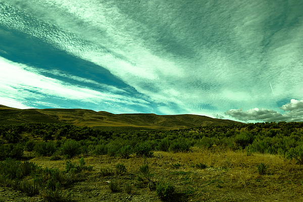
The Rattlesnake Hills is a 16-mile (26 km) long anticline mountain ridge in Yakima County and Benton County in the U.S. state of Washington. Also... more
Dimensions
1.80" W x 3.875" H x 0.90" D
Ships Within
1 - 2 business days

Photograph

Canvas Print

Framed Print

Art Print

Poster

Metal Print

Acrylic Print

Wood Print

Greeting Card

iPhone Case

Throw Pillow

Duvet Cover

Shower Curtain

Tote Bag

Round Beach Towel

Zip Pouch

Beach Towel

Weekender Tote Bag

Portable Battery Charger

Bath Towel

Apparel

Coffee Mug

Yoga Mat

Spiral Notebook

Fleece Blanket

Tapestry
The Rattlesnake Hills is a 16-mile (26 km) long anticline mountain ridge in Yakima County and Benton County in the U.S. state of Washington. Also known as Rattlesnake Mountain and Rattlesnake Ridge,[1] it should not be confused with the much smaller Rattlesnake Ridge located near the west end of Ahtanum Ridge.[2] Rattlesnake Hills' highest summit is 3,629 feet (1,106 m) tall, which is also the highest point in Benton County.[3] The Rattlesnake Hills are part of the Yakima Fold Belt of east-tending long ridges formed by the folding of Miocene Columbia River basalt flows.[4]
The Rattlesnake Hills form the northern edge of the Yakima Valley, running from the vicinity of Benton City to just south of the city of Yakima, where the Yakima River cuts through the mountain ridge via Union Gap. To the west of the Yakima River the mountain ridge is known as Ahtanum Ridge.
North of the Rattlesnake Hills is Moxee Valley and the Black Rock Valley. The hills extend into the Hanford S...
The world is a beautiful place and I intend to share it. With over nine hundred thousand views and hundreds of features etc I have done well. All my work is my own and I am self taught. My palette is often those places kind of hid away that have a special beauty. I enjoy sharing and selling my work and I have thousands of images that would love to find a home on your wall at home or at your office. As a gift such as a tote bag or a poster. I can be contacted at 509-306-5167 or at Jeffclimer@msn.com. Feel free to explore and share.
$46.00


Marian Bell
Beautiful processing!
Tami Quigley
Serene and beautiful Jeff ! L/F
Sandi OReilly
Gorgeous capture and amazing sky, great color, Jeff!!!! F/L